
How to Complete Incident Location/Address Fields
Posted: Aug. 14, 2023
- 3 min read
- Find similar NFIRSGrams:
- Basic Module
- Coding
This NFIRSGram provides National Fire Incident Reporting System (NFIRS) users with the information needed to consistently enter properly formatted address information. By doing so, you ensure that the information you enter in the incident report is used to help your fire department, state, and national groups learn and benefit from your fire incident experience.
With the rapidly expanding use of location-based analysis, geographic information systems (GIS) have proven very useful in developing new ways of analyzing fire incident data. In the future, the U.S. Fire Administration hopes to automatically generate location information for each reportable incident; however, currently the best way to enable GIS analysis is through geocoding incident address information.
Completing incident location/address fields
When filling out an incident report, include consistent, formatted, error-free address information. This increases the usefulness of the entire report and is the most effective way to enable analysis at the station, department, city, county, state, and even national level.
Key points for entering address information
- Select the appropriate “Incident Address Type” in the Location Type field (section B of the Basic Module). The most common Incident Address Type is “Street address,” but if you do not have a street number, something else might be better (e.g., “Intersection”).
- Ensure proper spelling of street and city name.
- Verify accurate 5-digit ZIP code.
- Include “MM” as part of the “Number/Mile” entry for highway locations based on mile markers or mileposts. For instance, a vehicle fire at Mile Marker 130 on North Bound I-95 in Florida would be:
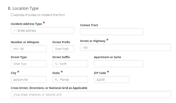
Note: You can use “Street address” as the “Address Type” for this situation. If you use directions, you are required to fill in the “Cross Street, Directions, or National Grid” field.
Description of incident field locations
Address Type:
Indicates whether it is a street address, directions from a recognized landmark, or an intersection of two roadways.
Census Tract:
The census tract number is a 6-digit number assigned by the U.S. Census Bureau, sometimes presented with a decimal before the last two digits — do not include this decimal when entering into the NFIRS. If the census tract is unknown, this is a convenient lookup tool — just enter the street address and ZIP code or city/state.
Number/Mile:
The number or milepost of the specific location where the incident occurred. For street addresses, enter only the street number; if entering a milepost or mile marker, include “MM” in the first two spaces of this field.
Street Prefix:
The directional descriptor appearing before a street or highway name. Your data entry tool should have predefined options for this field. Not all streets have a prefix.
Street or Highway Name:
The street or highway name where the incident occurred.
Street Type:
The street type descriptor appearing after a street or highway name. Your data entry tool should have predefined options for this field. Not all street names have a street type, such as “interstate.”
Street Suffix:
The directional descriptor appearing after a street or highway name. Your data entry tool should have predefined options for this field. Not all streets have a suffix.
Apartment, Suite or Room:
The number of the specific apartment, suite or room where the incident occurred. Leave blank if not applicable.
City:
The city where the incident occurred. If the incident occurred in an unincorporated area, use the city found in the mailing address for the incident location. Proper spelling is crucial.
State:
The state where the incident occurred.
ZIP code:
The numerical code assigned by the U.S. Postal Service to all U.S. jurisdictions. The 5-digit ZIP code is critical for geocoding. While nine digits (ZIP+4) are nice to have, the accurate 5-digit version is one of the crucial fields for geocoding.
Cross Street, Directions or U.S. National Grid (USNG):
Use directions only if the location cannot otherwise be identified, or when Cross Street, Directions, or U.S. National Grid are selected for Address Type. Enter USNG coordinates if U.S. National Grid is selected for location type (e.g., 18SUJ00539637 is the grid coordinate for the National Fire Data Center).
Recording incident location as: Intersection
- The Address Type should be coded as 2 – Intersection.
- Enter one street name in the Street Name field. Do not enter multiple street names in this field. Do not enter anything in the Number/Mile Marker field.
- In the Cross Street, Directions. or National Grid field, enter the name of the other street(s) of the intersection where the incident happened.
- There is no official designation about which street should be entered in the Street or Highway field and which one(s) should be entered int the Cross Street field.
Recording incident location as: Directions
- The Address Type should be coded as 6 – Directions. Use directions only if the location cannot otherwise be identified.
- In the Cross Street, Directions, or U.S. National Grid (USNG) field, enter the nearest address to the location of the incident. This may be a Mile Marker on a highway. For example, ¼ mile N of MM 65, or 500 yards N of address.
- The Street Name field in Section B. Location is optional when using the Address Type 6 – Directions. However, it is recommended to use these address fields if the Directions are not USNG, as the field only permits a maximum of 30 characters.